Lynx Trail - Stage 09 Palfau-Lassing, main route


- Multi-day tour
Interactive elevation profile
Create PDF
Tour-Details
Great efforts offer rich rewards: A long but scenically stunning trek to Mendling Valley
Technique: ***
Quality of experience: ******
Recommended season:
- May
- June
- July
- August
- September
- October
Properties:
- Multi-stage route
- Scenic
- Refreshment stops available
for this stage there is a longer version: Luchs-Trail Etappe 09 Palfau-Lassing, Variante Lang
Directions:
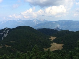
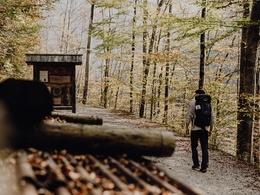
The standard version of today’s trek leads via the Moaralm cabin: Starting out from the Stiegenwirt inn (your accommodation in Palfau), you follow hiking path no. 284, walking along the forest road (which also doubles as a mountain bike touring route) until you reach the Moaralm cabin. Here, the mountain bike track turns off to the right, while you keep going straight along the forest road towards the ‘Naturfreundehütte’. After just 100 metres, you enter trail no. 284 towards the Moarhochalm alpine pasture (situated at an altitude of 1550 m), which is set between the peaks of the Gamsstein and Hasenfuß mountains. From the Moarhochalm alpine pasture, you follow the signs for Niederscheibenberg/Sandgraben/Hollenstein. Your trail (no. 64) takes you downhill to a forest road. Now head towards Sandgraben/Hollenstein, until you reach the Niederscheibenberg alpine pasture. Follow the first sign towards Sandgraben/Hollenstein, after which you keep to the signposts for mountain bikes, marked ‘Große Scheibenbergrunde 76’. After a brief stretch leading steeply uphill, you will spot another mountain-bike signpost on the crest of the forest road. Turn right towards ‘Gamssteintour neu’; at the next signpost, you walk straight on, once again following the sign for ‘Gamssteintour neu’. This stretch, which takes you along the forest road, is long but very pleasant. On hot summer’s days, the woodlands offer plenty of welcome shade. When the forest road joins a paved road, you keep left in order to cross a bridge, and then follow the flow of the stream until you have reached the ‘Erlebniswelt Mendlingtal’ educational trail: the last leg of the journey takes you through the gorge of the Mendling river, with informative displays along the way offering insights into the historical practice of timber logging on the Mendling river. Level of difficulty: medium Hiking time: 7 hrs 30 minDistance: 21.9 kmAscent: 1152 mDescent: 1017 mIf the previous stages of the Luchs Trail have left you with some energy to spare, you might like to complete this last stage on a more demanding, alternative route. This variation runs via the summit of the Gamsstein mountain – adding another hour to your journey, but rewarding you with the most stunning scenery. Starting out from your accommodation in Palfau, you head West through the village until you reach a bridge (situated east of the village church). A narrow, gently ascending road will take you up to the ‘Bergbauer’ farmstead, where you follow the signs for the ‘Naturfreundehütte’ (an infrequently occupied mountain hostel), which you reach after a short while. Now continue through some wild woodlands (even trees that have previously fallen in a storm have not been removed in order to maintain the forests’ natural cycle). Next, you embark on a steep ascent through creeping pines and over grassland pastures, until you have reached the Gamsstein summit (1770 m) – where you can enjoy stunning panoramic views of the Totes Gebirge, Gesäuse, Hochschwabmassiv and Dürrenstein mountain ranges. For your ascent, you follow the signs for Hollenstein, hiking first along the ridge, then in between patches of creeping pine, all the way down to the Moarhochalm alpine pasture (1550 m). The rest of the way – leading to Lassing – is identical to the standard route (see above).
Tip:
Top tip:
For more information:
We recommend that you make contact with the Lynx Trail Info & Booking Centre before making a booking.
Find a deal at:
Safety guidelines:
Mountain Rescue 140
Equipment:
Sturdy mountain walking boots or trail shoes, as well as a rucksack packed with essentials (water bottle, plasters for blisters, trail map, food etc.). You should also be well prepared for changes in the weather. If you are staying overnight in mountain huts don’t forget your sleeping bag!
Additional information:
Hints and tips
Lynx Trail Info & Booking Centre
Trail Angels GmbH
Obervellach 15, 9821 Obervellach
Tel.: +43 47 82 93 093
Email: info@bookyourtrail.com
Lower Austria Information Office:
Mostviertel Tourismus GmbH
Töpperschloss Neubruck
Neubruck 2/10, 3283 Scheibbs
Tel.: +43 (0) 7482 204 44
Email: info@mostviertel.at
Upper Austria Information Office:
Tourismusverband Nationalpark Region Ennstal
Eisenstraße 75, 4462 Reichraming
Tel.: +43 (0) 7254 8414
Email: info@nationalparkregion.com
Steiermark Information Office:
Tourismusverband Gesäuse
Hauptstraße 35, 8911 Admont
Tel. +43 (0) 3613 21160 10
Email: info@gesaeuse.at
further information:
- Multi-day tour
- Board possible


Getting there
Public Transit
In the Gesäuse you are mobile even without your own car
One call to t: +43 3613 21 000 99 is enough: During operating times, you can take the Gesäuse Sammeltaxi to any destination in the Gesäuse, without any timetable or stops.
Further information & operating times
Timetable inquiry at www.oebb.at or www.busbahnbim.at
Parking
Parking facilities are available at the respective starting points, which are subject to a charge, especially in the Gesäuse National Park area.
Tip: Please leave a note in your car with your telephone number and the date of your return, together with a note that you are on a hike lasting several days. The mountain rescue service will thank you!
- Spring
- Summer
- Autumn
Please get in touch for more information.
Interactive elevation profile
Create PDF
