Lynx Trail - Stage 11 Göstling (Hochreit) - Lunz am See (Seehof), without shuttle


- Multi-day tour
Interactive elevation profile
Create PDF
Tour-Details
Paths covering:
Grand Finale: Hiking over the Dürrenstein mountain and through the enchanting Seetal valley, before you rest on the shores of the ‘Lunzer See’ lake
Technique: ***
Quality of experience: ******
Recommended season:
- May
- June
- July
- August
- September
- October
Properties:
- Multi-stage route
- Scenic
- Refreshment stops available
If this stage is too long for you there is the posibility of a shuttle: Luchs Trail Etappe 11 Hochreit-Seehof, mit Shuttle
Directions:
A shuttle taxi will pick you up from your accommodation in Göstling after breakfast, and drive you to the Steinbachtal valley – dropping you off at the car park commonly used as a departure point for the Ybbstaler Hütte mountain. This saves you almost 2 hours of hiking, ensuring that today’s comparatively challenging itinerary stays reasonably manageable.
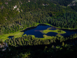
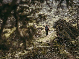
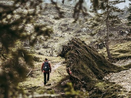
Starting out from the car park, you follow the signposts for the ‘Ybbstaler Hütte’ mountain hostel (elevation gain from car park: 730) – walking first on a forest road, then on a clearly marked footpath until you have reached a hunter’s cabin. This is where you cross the forest road. After a natural spring, you turn left onto yet another forest road. Shortly afterwards, you turn right, leaving the forest road for a steep ascent, until you reach the forest road that will take you all the way up to the Ybbstaler Hütte. From the Ybbstaler Hütte, you head south-east, walking up a moderate incline through the sparsely forested Karsttrockental valley, where the effects of recent heavy storms are still visible. The route continues to follow a gentle incline, past several karst hollows and sinkholes, before a steeper stretch takes you up to the Legsteinalm pasture (where you will spot an alpine cabin that has been repurposed as a Mountain Rescue base). At the Legstein hunter’s mountain, you pass the Jungfraunbründl spring. You are now in the north-eastern part of the Dürrenstein Nature Reserve, whose total area encompasses around 3500 hectares. At the centre of this remarkable conservation area is the Urwald Rothwald, one of the largest remaining primeval forests in Central Europe, which has been declared a ‘Category 1a’ protected area by the International Union for the Conservation of Nature (IUCN). As you continue on your journey, the rocky trail takes you across karst terrain and in between creeping pines, all the way up to an undulating plateau. Around 2 hours after leaving the Ybbstaler Hütte (mountain hostel), you have reached the Dürrenstein summit (1878 m), marked with a beautifully crafted, iron cross – the perfect place for a well-deserved rest whilst enjoying stunning panoramic views. Your descent to the ‘Leonhardikreuz’ – a junction of hiking paths marked by a cross (1406 m) leads first through dwarf-pine shrubs, and then across the alpine meadows of the Herrenalm pasture. If you have some time and energy to spare, adding 15 minutes’ walk for a stop-over at the ‘Herrenalmhütte’ mountain hostel is well worth the effort. Having returned to the Leonhardikreuz junction you embark on a steep descent to the idyllic Obersee lake. From there, a forest road takes you through the romantic wilderness of the Seetal valley. Having passed a karst feature known as the ‘Roaring Bull’ (an underground waterfall) and the Ludwigfall (a waterfall that plummets down a vertical, 50-metre high cliff), you arrive at Mittersee lake. To the east, the landscape is dominated by the craggy rock-faces of the Hackermäuer range, while the ‘Seemäuern’ and the ‘Höherstein’ mountains characterise the landscape to the west. From Mittersee lake, you continue on the signposted path, heading out of the Seetal valley until you arrive in ‘Seehof am Lunzer See’ – a small hamlet on the picturesque Lunzer See lake. You have now reached the end of your hiking journey on the Luchs Trail. Why not take a little rest in this lovely spot, refresh tired feet in the cool waters of the crystal-clear mountain lake, and think back over the adventures of the past few days. If you have opted to spend the night in the alpine club mountaineering village of Lunz, a shuttle will take you to your chosen accommodation. For the following day, we highly recommend exploring the picturesque village of Lunz am See. In the late middle ages, it was home to a thriving iron industry: the architecturally impressive ‘Amonhaus’ still serves as a reminder of the great wealth of that time. The noble mansion, where even Emperor Franz I stayed, today houses the town hall, as well as the Hammerherren and Handicrafts Museum.
The official end point of the Lynx Trail is the World Heritage Center "House of the Wild" directly in the town center. Experience the last primeval forest in Central Europe without harming the flora and fauna of this sensitive habitat. Thanks to interactive technology, you will gain unforgettable insights into the wilderness, the primeval forest and the "forest network" on more than 700 m² of exhibition space.
Tip:
Top tip:
For more information:
We recommend that you make contact with the Lynx Trail Info & Booking Centre before making a booking.
Find a deal at: www.bookyourtrail.at
Safety guidelines:
Mountain Rescue 140
Equipment:
Sturdy mountain walking boots or trail shoes, as well as a rucksack packed with essentials (water bottle, plasters for blisters, trail map, food etc.). You should also be well prepared for changes in the weather. If you are staying overnight in mountain huts don’t forget your sleeping bag!
Additional information:
Hints and tips
Lynx Trail Info & Booking Centre
Trail Angels GmbH
Obervellach 15, 9821 Obervellach
Tel.: +43 47 82 93 093
Email: info@bookyourtrail.com
Lower Austria Information Office:
Mostviertel Tourismus GmbH
Töpperschloss Neubruck
Neubruck 2/10, 3283 Scheibbs
Tel.: +43 (0) 7482 204 44
Email: info@mostviertel.at
Upper Austria Information Office:
Tourismusverband Nationalpark Region Ennstal
Eisenstraße 75, 4462 Reichraming
Tel.: +43 (0) 7254 8414
Email: info@nationalparkregion.com
Steiermark Information Office:
Tourismusverband Gesäuse
Hauptstraße 35, 8911 Admont
Tel. +43 (0) 3613 21160 10
Email: info@gesaeuse.at
further information:
- Multi-day tour
- Board possible


- Spring
- Summer
- Autumn
Please get in touch for more information.
Stadtplatz 27
4400 Steyr
Phone +43 7252 53229 - 0
E-Mail info@steyr-nationalpark.at
Web www.steyr-nationalpark.at/
Interactive elevation profile
Create PDF
Tour-Details
Paths covering:
