Lynx Trail - Stage 05 Klinkehütte-Johnsbach


- Multi-day tour
Interactive elevation profile
Create PDF
Tour-Details
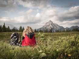
Broaden your perspective: Hiking to the mountaineering village of Johnsbach whilst enjoying spectacular views of the rugged Gesäuse mountains
Technique: ***
Quality of experience: ******
Recommended season:
- May
- June
- July
- August
- September
- October
Properties:
- Multi-stage route
- Scenic
- Refreshment stops available
Broaden your perspective: Hiking to the mountaineering village of Johnsbach whilst enjoying spectacular views of the rugged Gesäuse mountains
Directions:
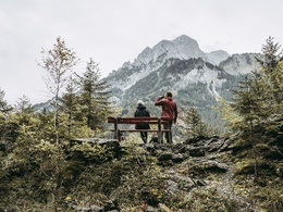
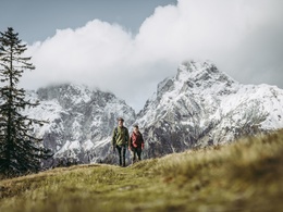
From the Klinkehütte mountain hostel, it’s only a few minutes’ walk up to the Kalblinggatterl saddle, before you embark on the two-hour hike to the Mödlinger Hütte mountain hostel. Simply follow the markings (hiking paths no. 01 and 08) as you head down to the idyllic Flitzenalm pasture, where you are treated to a fantastic view of the majestic Admonter Reichenstein (2251 m). This mountain was long thought to be impossible to climb, until a group of pioneers set out from the Flitzenalm in 1873, reaching the summit via the mountain’s rugged south-face. From the Hintere Flitzenalm cabin, the route alternates between footpaths and forest roads, until you arrive at the Mödlinger Hütte mountain hostel (1523 m): its extraordinary position on the crest of the Treffneralm pastures opens up glorious panoramic views of the Ödstein, Admonter Reichenstein and Sparafeld summits. After a stop-over, you follow trail no. 601/608 (heading South-East), and it won’t be long before you have reached the summit cross of the Spielkogel (1731 m). From there, you traverse the ridge to the Anhartskogel (1764 m) and then the Niederberg. Now keep a lookout to your left for a sign to ‘Johnsbach, Weg Nr. 675’, which takes you down to the former Wölgeralm cabin. Take care not to lose your trail in the open grassland terrain. Having passed the cabin, keep to the left (in other words, west) of the stream that runs through the Sebringgraben valley. Please be aware that after a downpour, this path can be slightly slippery. Next you traverse the Wolfsbacher-Niederalm pasture, walking past the cabin and continuing on a footpath to the left of the river, into an ancient mountain forest. Eventually the path leads to a forest road, which you follow to the famous alpine club mountaineering village of Johnsbach.
Tip:
For more information:
We recommend that you make contact with the Lynx Trail Info & Booking Centre before making a booking.
Find a deal at: bookyourtrail.com
Safety guidelines:
Mountain Rescue 140
Equipment:
Sturdy mountain walking boots or trail shoes, as well as a rucksack packed with essentials (water bottle, plasters for blisters, trail map, food etc.). You should also be well prepared for changes in the weather. If you are staying overnight in mountain huts don’t forget your sleeping bag!
Additional information:
Hints and tips
Lynx Trail Info & Booking Centre
Trail Angels GmbH
Obervellach 15, 9821 Obervellach
Tel.: +43 47 82 93 093
Email: info@bookyourtrail.com
Lower Austria Information Office:
Mostviertel Tourismus GmbH
Töpperschloss Neubruck
Neubruck 2/10, 3283 Scheibbs
Tel.: +43 (0) 7482 204 44
Email: info@mostviertel.at
Upper Austria Information Office:
Tourismusverband Nationalpark Region Ennstal
Eisenstraße 75, 4462 Reichraming
Tel.: +43 (0) 7254 8414
Email: info@nationalparkregion.com
Steiermark Information Office:
Tourismusverband Gesäuse
Hauptstraße 35, 8911 Admont
Tel. +43 (0) 3613 21160 10
Email: info@gesaeuse.at
further information:
- Multi-day tour
- Board possible


Getting there
Public Transit
In the Gesäuse you are mobile even without your own car
One call to t: +43 3613 21 000 99 is enough: During operating times, you can take the Gesäuse Sammeltaxi to any destination in the Gesäuse, without any timetable or stops.
Further information & operating times
Timetable inquiry at www.oebb.at or www.busbahnbim.at
Parking
Parking facilities are available at the respective starting points, which are subject to a charge, especially in the Gesäuse National Park area.
Tip: Please leave a note in your car with your telephone number and the date of your return, together with a note that you are on a hike lasting several days. The mountain rescue service will thank you!
- Spring
- Summer
- Autumn
Please get in touch for more information.
Interactive elevation profile
Create PDF
