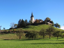
Benedikt Pilgerweg OÖ - Frauenstein bis Schlierbach


- culturally interesting
- Multi-day tour
Interactive elevation profile
Create PDF
Tour-Details
Paths covering:
The Benedict Path connects the provinces of Upper Austria, Styria and Carinthia as well as the Benedictine centres of Admont, Seckau and Sankt Paul im Lavanttal.
Quality of experience: ***
Recommended season:
- March
- April
- May
- June
- July
- August
- September
- October
Properties:
- Multi-stage route
- Scenic
- Cultural/historical value
The stage from Frauenstein to Schlierbach leads via Göritz to the Steyrdurchbruch, along the Prälatenweg to Micheldorf, then to Altpernstein Castle and via the Habinger Cross and the Grillenparz to Schlierbach.
Trail number: 404/409, 15, K91, K92, K85
Benedikt Pilgerweg OÖ N10
Directions:
Frauenstein - Schlierbach:
From the pilgrimage church of Frauenstein, the route follows the Steyrtal valley in the direction of Göritz, past the Steyr Durchbruch and along the Prälatenweg 15 to Micheldorf and Burg Altpernstein. From there, continue along the Prälatenweg to the Haringerkreuz and via Grillenparz down to Schlierbach Abbey.
Tip:
Plan enough time for the sights and for the magnificent views along the way and take a break with water at Echt arg Gin & Spirituosen!
Safety guidelines:
Aufgrund unterschiedlicher Kartenmodelle kann es bei der Route in der Darstellung zu Abweichungen kommen.
Die Originalrouten sind auf der Website der Benedikt-bewegt-Gruppe zu finden.
Etappe N10 Klaus/Pyhrnbahn - Schlierbach
Additional information:
Micheldorf:
- Detour to the Hirschwaldstein (1.095m)
- Round in the village to the Georgenberg and the Garden of Passion
further information:
- Multi-day tour
Package bookable from Monday - Saturday


Getting there
From Vienna/Salzburg: A1 towards Linz > A9 Pyhrnautobahn - exit Inzersdorf.
From Linz: A9 Pyhrn motorway - exit Inzersdorf
From Graz: A9 Pyhrnautobahn > exit Klaus > federal road B 138
Public Transit
Arrival with the Pyhrnbahn, there are stops in Schlierbach, Kirchdorf/Krems and Micheldorf.
Details at www.ooevv.at
Parking
Klaus an der Pyhrnbahn
- Spring
- Summer
- Autumn
Please get in touch for more information.
Stadtplatz 27
4400 Steyr
Phone +43 7252 53229 - 0
E-Mail info@steyr-nationalpark.at
Web www.steyr-nationalpark.at/
Interactive elevation profile
Create PDF
Tour-Details
Paths covering:


