Following the former Waldbahn route from Reichraming, Hintergebirgsradweg


Cycling tour on the Hintergebirgsradweg from Reichraming with gentle slopes to Weißwasser and a short, steeper ascent to the Hirschkogel saddle, then a descent to Brunnbach.
Open: April 15 - end of October!
Recommended season:
- May
- June
- July
- August
- September
- October
- Loop
- Refreshment stops available
- Family friendly
- Cultural/historical value
- Geological highlights
- Botanical highlights
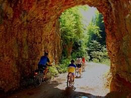
The bike path leads on the former Waldbahn track into the Hintergebirge of Reichraming, the heart of the Kalkalpen National Park. The loop covers 46 adventurous kilometers with an elevation difference of 522 meters. From the Anzenbach parking lot to the managed Klaushütte, the route is also suitable for families with children due to gentle inclines!
From the Klaushütte, the cycling route runs along the Große Bach to the Annerlsteg and to Weißwasser. Here, 23 kilometers are done. Many bikers turn back here to enjoy the return ride along the green and pristine streams once more. However, those who want to complete the circular route via Brunnbach need some stamina. On nearly 5 kilometers, 200 meters of elevation must be overcome to the Hirschkogel saddle. From there, it’s a long downhill ride to Brunnbach and then following the Plaißabach back to Maieralm, where the loop closes. The familiar path then leads back to the starting point.
Directions:Starting from the train station in Reichraming, we cycle into the town center of Reichraming. Then we follow the Reichramingbach along Anzenbachstraße to the Anzenbach parking lot. Here, the route separates from the public road, turning right onto Waldbahnstraße into the Hintergebirge. Without noticeable incline, we cycle to the Maieralm junction. WARNING! Don’t be deceived by the stream course. We cross the Plaißabach and then follow the Große Bach on the right.
After about 1 1/4 hours of cycling (and approximately 14.5 kilometers from Reichraming train station), we arrive at what was once the most important log driving construction in the Hintergebirge. The Große Klause is the oldest log sluice in the Hintergebirge. For the 11.6-kilometer log drive route to the Schallauer-Rechen in Reichraming, the wood took one hour from here.
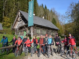
Just a few meters away is the managed KLAUSHÜTTE. Built in 1758, it served as accommodation for timber workers. Today it is a National Park service station for thirsty and hungry cyclists and hikers. The Klaushütte is open from May 1 to mid-October (weather permitting), Wednesday to Sunday and on public holidays from 9 am to 7 pm.
We cycle along the Große Bach between Bärenmauer and Teufelsgraben, past the Keixen, until we reach the entrance to the Große Schlucht. At the Annerlsteg, there is a small shelter with a table and benches, inviting for a cozy break.
TIP TRIFTSTEIG:
Here at the Annerlsteg, you can start the TRIFTSTEIG. This approximately 2-kilometer-long gorge via ferrata secured with steel cables follows the old path of the former Triftsteig, which was equipped only with narrow wooden planks. From here, the bold timber workers drove logs through the gorges during high water down to Reichraming and further to the Enns river.
The narrow, partly exposed trail requires sure-footedness and a head for heights. Recommended only for experienced hikers! Return to the starting point at the Annerlsteg by forest road and through several long tunnels (a flashlight or headlamp is helpful).
Our bike path now leads us through several longer tunnels of the former Waldbahn. At kilometer 20, you will reach the Schleierfall (waterfall), where the Hochlachtbach drops to the Schwarzen Bach. We continue cycling between Hörndlmauer and Preflingkogel along the Schwarzen Bach to Weißwasser.
- Note system error: The steep parts between kilometers 18 and 21 do not actually exist; the route is flat through tunnels of the former Waldbahnstraße. (Total distance 46 kilometers, elevation gain approx. 522 meters)
TIP VIRTUAL WEISSWASSER EXPERIENCE TRAIL:
It is hardly imaginable that once around 1,000 people lived here in Weißwasser, who even had their own school and shop. This was a larger settlement for workers for the bauxite mining in the Blaberg, Prefing, and Schwarza areas.
A new VIRTUAL WEISSWASSER EXPERIENCE TRAIL now accompanies a short section of the Hintergebirgsradweg: Using augmented reality, the historically significant mining settlement from the 1960s in Weißwasser is virtually visible and experienceable again. The app for the trail is available free of charge but must be downloaded to your smartphone before starting the cycling tour. (No mobile reception or internet connection in Weißwasser)
From Weißwasser, a bit of stamina is required. You have to overcome 200 meters of elevation on nearly 5 kilometers to Hirschkogel saddle. Once at the top, take the opportunity to rest.
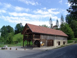
TIP! From here, a detour to the managed ANLAUFALM is recommended, about 30 minutes on foot via the hiking trail to the alpine pasture or a good 5 kilometers by bike around Sonnberg. The Anlaufalm is managed from May 1 to the end of October.
From Hirschkogel saddle, it’s then a long downhill ride to the small village of Brunnbach. First, you will see the BRUNNBACHSTADL SNACK STATION, here you turn left and continue along the Plaißabach, gently descending until you return to the Maieralm. Here the circular route closes and you cycle back along the familiar path to the Anzenbach parking lot and further to Reichraming.
Tip:- Please don't forget to save the route "offline" before you set off, as mobile reception in the forest wilderness of the national park is not always available.
- WORTH SEEING! The Virtual Weißwasser Experience Trail is located directly on the Hintergebirgsradweg between the junction to the Weißwasser bivouac site and the junction to the Hirschkogel saddle. Using augmented reality, the historically significant miners' settlement from the 1960s in Weißwasser is virtually made visible and experienceable again. Please download the Android app to your smartphone before visiting the experience trail. No internet connection is available on site! Google Play: Download Weißwasser AR (iOS app coming soon)
Please note: Cycling and mountain biking in the national park area is only permitted from April 15 to October 31, from 2 hours after sunrise until 1 hour before sunset! The exception is the Langfirst mountain bike trail, where the bike season begins only on June 1. Cycling and mountain biking are only permitted on marked routes. Some bike paths are simultaneously designated as hiking trails or riding trails. Always expect oncoming hikers or riders!
Equipment:Bicycle, mountain bike, bike helmet, drinks and snacks for the trip
For hot summer days – pack swimwear! Along the route, you can often descend to the stream and rest at sunny gravel banks or take a refreshing swim in the crystal-clear water. (Please watch children carefully, as the water flow is sometimes strong.)
Additional information:Paths covering:
further information:
- Flatly
- Board possible


Getting there
Via the Eisenbundesstraße (B115)
from 4400 Steyr - 4452 Ternberg - 4462 Reichraming town center - Dirnbach district - Anzenbach parking lot
from 3335 Weyer - 4463 Großraming - 4462 Reichraming town center - Dirnbach district - Anzenbach parking lot
Public Transit
Arrival by train to Reichraming train station possible.
Parking
Parking spaces in the town center of Reichraming
Schallau parking lot (free of charge)
Dirnbach parking lot (free of charge!)
Weißenbach parking lot, dry toilets and info point on site (chargeable from May 1 - October 31)
Anzenbach parking lot near Reichraming, toilet facilities and info point on site (chargeable from May 1 - October 31)
- Spring
- Summer
- Autumn
Please get in touch for more information.
