Wolfsgruberau circular hiking trail
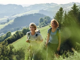


Hike through forests past the wind turbines with a magnificent view of the gentle rolling hills
Recommended season:
- March
- April
- May
- June
- July
- August
- September
- October
- November
- Loop
- Scenic
Following the Kotleiten forest road, you circle the Plattenberg with the wind turbines, pass the Plattner chapel, briefly follow the paved road, and return over the meadow and through the forest back to the starting point.
Hiking trail: E53
Directions:The path initially leads along a trail to the Kotleiten forest road. Following this, shortly before the farm 'Simmerl im Wald,' you reach a junction where you turn right. You follow this road with a slight ascent until the hiking trail branches off into the forest. After a few minutes, you reach the Plattner chapel. From here, the path leads along a paved road to below the wind park. Here the path leads right over the meadow beneath the wind turbines and then through the forest back to the starting point.
Paths covering:
further information:
- Flatly
Accessible May to October


Getting there
From Salzburg/Linz: A1 motorway exit Enns-Steyr > B115 into the Enns Valley
From Vienna: A1 motorway exit Haag > B42 > B122 > B115 into the Enns Valley
From Passau: A8 Passau > Wels > A1 motorway exit Enns-Steyr > B115 into the Enns Valley
From Graz: A9 Pyhrnautobahn > motorway exit Klaus > Grünburg > into the Ennstal Valley
Public Transit
The Ennstalbahn runs between Linz and Weißenbach-St. Gallen.
Details at www.ooevv.at
Railway Stations are located in Steyr, Garsten, Lahrndorf, Dürnbach, Ternberg, Trattenbach, Losenstein, Reichraming, Großraming, Gaflenz, Weyer, Küpfern, Kastenreith, Kleinreifling and Weißenbach-St. Gallen.
Parking
Laussa/Wolfsgruberau parking lot
- Suitable for seniors
- Suitable for single travelers
- Suitable for friends
- Suitable for couples
- Spring
- Summer
- Autumn
- Early winter
Please get in touch for more information.
Stadtplatz 27
4400 Steyr
Phone +43 7252 53229 - 0
E-Mail reichraming@steyr-nationalpark.at
Web www.steyr-nationalpark.at/
