Schoberstein from Trattenbach/Gasthaus Klausriegler


4400 Steyr

Easy mountain hike on an uncomplicated but partially steep path
Recommended season:
- January
- February
- March
- April
- May
- June
- July
- August
- September
- October
- November
- December
- Round trip
- Scenic
- Refreshment stops available
- Summit route
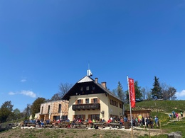
From the Klausriegler inn in Trattenbach, this well-marked hiking trail leads steadily uphill, over a pasture, through forests, and then over a high plateau to the summit of Schoberstein (1,285 m). The Schobersteinhaus is located nearby and invites you to stop for refreshments.
Note: A parking fee applies at the Klausriegler alpine inn. If you make a purchase, you receive a token to exit.
Variation: Extension by about an hour if starting from Trattenbach train station. This route passes through the open-air museum village “In the Valley of the Feitlmacher.”
Tip: Descending via Mandlmais and Scheibachfall (mostly forest road) turns this summit hike into a circular walk.
Hiking trail: 491, circular hike 483, 21, E77
Directions:From the Klausriegler inn in Trattenbach, this well-marked hiking trail leads steadily uphill, over a pasture, through forests, and then over a high plateau to the summit of Schoberstein (1,285 m). The Schobersteinhaus is located nearby and invites you to stop for refreshments.
Tip: Descending via Mandlmais and Scheibachfall (mostly forest road) turns this summit hike into an extended circular hike. From the Schobersteinhaus, head east along the mountain ridge toward Koglerstein/Schinder and descend through the forest, passing the idyllic Mandlmais chapel and later the Scheibachfall, then continue on the forest road back to the starting point.
Paths covering:
further information:
- Possible accommodation
- Board possible


Getting there
From Salzburg/Linz: A1 motorway exit Enns-Steyr > B115 into the Enns Valley.
From Vienna: A1 motorway exit Haag > B42 > B122 > B115 into the Enns Valley
From Passau: A8 Passau > Wels > A1 motorway exit Enns-Steyr > B115 into the Enns Valley
From Graz: A9 Pyhrnautobahn > motorway exit Klaus > Grünburg > into the Ennstal valley
Public Transit
The Ennstalbahn runs between Linz and Weißenbach-St. Gallen.
Details at www.ooevv.at
Railway Stations are located in Ternberg, Trattenbach, Losenstein, Reichraming, Großraming, Gaflenz, Weyer, Küpfern, Kastenreith, Kleinreifling and Weißenbach-St. Gallen.
Parking
Trattenbach/Gasthaus Klausriegler for a fee
If you make a purchase, you receive a token to exit.
- Suitable for groups
- Suitable for teenagers
- Suitable for seniors
- Suitable for single travelers
- Suitable for friends
- Suitable for couples
- Suitable for children
- Spring
- Summer
- Autumn
- Early winter
- Deep winter
Please get in touch for more information.
Stadtplatz 27
4400 Steyr
Phone +43 7252 53229 - 0
E-Mail reichraming@steyr-nationalpark.at
Web www.steyr-nationalpark.at/
")
