natur.BANK.wege | Großraming | Prennhöhe | 446309


- Suitable for families
Interactive elevation profile
Create PDF
Tour-Details
Starting place: 4463 Großraming
Destination: 4463 Großraming
duration: 1h 15m
length: 3,6 km
Altitude difference (uphill): 320m
Altitude difference (downhill): 6m
Lowest point: 375m
Highest point: 700m
difficulty: medium
condition: medium
panoramic view: Dreamtour
Paths covering:
Asphalt, Path / trail, Gravel
powered by TOURDATA
Short description:
Cosy hiking tip for a Sunday afternoon
Cosy hiking tip for a Sunday afternoon
Quality of experience: *****
Recommended season:
- January
- February
- March
- April
- May
- June
- July
- August
- September
- October
- November
- December
Properties:
- Family friendly
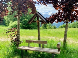
The Prennhöhe is an idyllic place to linger and recharge your batteries.
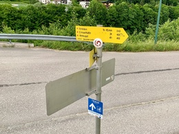
Directions:
From the Großraming railway station car park, follow the marked trail E43 to the Hagauer vulgo Kronsteiner farm and continue on the forest road through dense forest to an alpine hut. Shortly above the hut, a tractor path leads to the Prennhöhe, where there is also a bench in the middle of a flowery meadow near a wayside shrine.
Tip:
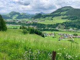
From the Prennhöhe it is not far to the summit of the Rotstein, a beautiful vantage point to Großraming and the Lumplgraben into the Kalkalpen National Park. As a way back, you can take the path to Hinterlangerbauern, from where you hike back through the Lumplgraben to the starting point. Also recommended as a winter hike.
Additional information:
Refreshment stops in the vicinity
Starting point: Großraming railway station
Destination: natur.BANK.wege Prennhöhe
Accessibility / arrival
Getting there
By train: the Ennstalbahn runs between Linz and Kleinreifling.By car from Linz: A1 motorway exit Enns-Steyr > B115 into the Ennstal valley.By car from Vienna: A1 motorway exit Amstetten West > Waidhofen / Ybbs > Weyer > Großraming
Parking
Station car park
Most economical season
- Spring
- Summer
- Autumn
- Early winter
- Deep winter
Please get in touch for more information.
Stadtplatz 27
4400 Steyr
Phone +43 7252 53229 - 0
E-Mail info@steyr-nationalpark.at
Web www.steyr-nationalpark.at/
https://www.steyr-nationalpark.at/
Interactive elevation profile
Create PDF
Tour-Details
Starting place: 4463 Großraming
Destination: 4463 Großraming
duration: 1h 15m
length: 3,6 km
Altitude difference (uphill): 320m
Altitude difference (downhill): 6m
Lowest point: 375m
Highest point: 700m
difficulty: medium
condition: medium
panoramic view: Dreamtour
Paths covering:
Asphalt, Path / trail, Gravel
powered by TOURDATA
