Blahbergalm via Weißwasser


Interactive elevation profile
Create PDF
Tour-Details
Starting place: 3335 Weyer
duration: 1h 24m
length: 3,7 km
Altitude difference (uphill): 448m
Altitude difference (downhill): 84m
Lowest point: 592m
Highest point: 1.040m
difficulty: medium
condition: medium
panoramic view: Some Views
Paths covering:
Path / trail, Gravel, Hiking trail, Other
powered by TOURDATA
Short description:
Hike from the former bauxite mining area Weißwasser to the Blahbergalm
Hike from the former bauxite mining area Weißwasser to the Blahbergalm
Quality of experience: ***
Recommended season:
- May
- June
- July
- August
- September
- October
Properties:
- Refreshment stops available
- Geological highlights
From the Weißwasser parking lot below the Mooshöhe, hike along the Schwarze Bach stream to the bivouac site and then steadily uphill to the Blahbergalm (1,041m).
Trail number: 475
Directions:
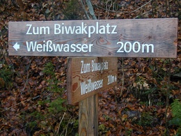
From the Weißwasser parking lot, hike along the Schwarze Bach stream on the Hintergebirgsradweg trail to the junction to the Weißwasser bivouac site.
Here you turn left and follow the forest road to the bivouac site and then continue steadily uphill to the Blahbergalm.
Tip:
Ehemalige Bauxit-Bergwerksstollen und Knappenhaus unterhalb der Blahbergalm (verfallen)
Additional information:
The hiking trail 475 actually starts at the Hirschkogelsattel and leads from the Blahbergalm still further over the Ahronsattel to the Dörflmoaralm at the Hengstpass in the direction of Windischgarsten.
Starting point: Weyer-Unterlaussa/parking lot Weißwasser below Mooshöhe
Destination: Blahbergalm
further information:
- Board possible

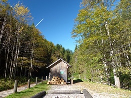
Biwakplatz Weißwasser
Accessibility / arrival
Public Transit
The Ennstalbahn runs between Linz and Weißenbach-St. Gallen.
Parking
Weyer - Unterlaussa/parking lot Weißwasser reachable via Mooshöhe
Getting there
From Salzburg/Linz: A1 motorway exit Enns-Steyr > B115 into the Enns Valley
From Vienna: A1 motorway exit Haag > B42 > B122 > B115 into the Enns Valley
From Passau: A8 Passau > Wels > A1 motorway exit Enns-Steyr > B115 into the Enns Valley
From Graz: A9 Pyhrnautobahn > motorway exit Klaus > Grünburg > into the Ennstal Valley
Public Transit
The Ennstalbahn runs between Linz and Weißenbach-St. Gallen.
Details at www.ooevv.at
Railway Stations are located in Steyr, Garsten, Lahrndorf, Dürnbach, Ternberg, Trattenbach, Losenstein, Reichraming, Großraming, Gaflenz, Weyer, Küpfern, Kastenreith, Kleinreifling and Weißenbach-St. Gallen.
Parking
Weyer - Unterlaussa/parking lot Weißwasser reachable via Mooshöhe
Most economical season
- Spring
- Summer
- Autumn
Please get in touch for more information.
Stadtplatz 27
4400 Steyr
Phone +43 7252 53229 - 0
E-Mail info@steyr-nationalpark.at
Web www.steyr-nationalpark.at/
https://www.steyr-nationalpark.at/
Interactive elevation profile
Create PDF
Tour-Details
Starting place: 3335 Weyer
duration: 1h 24m
length: 3,7 km
Altitude difference (uphill): 448m
Altitude difference (downhill): 84m
Lowest point: 592m
Highest point: 1.040m
difficulty: medium
condition: medium
panoramic view: Some Views
Paths covering:
Path / trail, Gravel, Hiking trail, Other
powered by TOURDATA
