Annerlsteig - Annerlalm - Wällerhütte


- Flatly
Interactive elevation profile
Create PDF
Tour-Details
duration: 2h 0m
length: 4,0 km
Altitude difference (uphill): 605m
Altitude difference (downhill): 595m
Lowest point: 509m
Highest point: 731m
difficulty: medium
condition: difficult
panoramic view: Dreamtour
Paths covering:
Path / trail, Gravel
powered by TOURDATA
Short description:
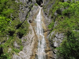
Hiking in the gorges of the Reichraminger Hintergebirge in the Kalkalpen National Park
Hiking in the gorges of the Reichraminger Hintergebirge in the Kalkalpen National Park
Quality of experience: *****
Recommended season:
- May
- June
- July
- August
- September
- October
Properties:
- Loop
- Geological highlights
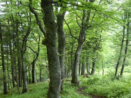
- Botanical highlights
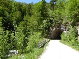
From the Annersteg at the entrance to the Great Gorge, the trail leads via the former Annerlalm up to the Wällerhütte and via the tunnels back to the starting point.
Trail number: 487
Directions:
The trail leads from Annerlsteg at the entrance to the Great Gorge via the former Annerlalm to the Wällerhütte and then joins hiking trail 470. Below the Annerlalm you have a magnificent view of the Great Gorge 200 meters below.
The journey to the starting point is recommended by bike or via the Weißwasser parking lot in Unterlaussa.
Starting point: Reichraminger Hintergebirge/Große Schlucht
Destination: Reichraminger Hintergebirge/Große Schlucht
further information:
- Flatly
Accessibility / arrival
Public Transit
The Ennstalbahn runs between Linz and Weißenbach-St. Gallen.
Parking
The journey to the starting point of the hike is recommended by bike from Reichraming or on foot from the parking lot Weißwasser in Unterlaussa reachable via the Mooshöhe.
Getting there
From Salzburg/Linz: A1 motorway exit Enns-Steyr > B115 into the Enns Valley
From Vienna: A1 motorway exit Haag > B42 > B122 > B115 into the Enns Valley
From Passau: A8 Passau > Wels > A1 motorway exit Enns-Steyr > B115 into the Enns Valley
From Graz: A9 Pyhrnautobahn > motorway exit Klaus > Grünburg > into the Ennstal Valley
Public Transit
The Ennstalbahn runs between Linz and Weißenbach-St. Gallen.
Details at www.ooevv.at
Railway Stations are located in Steyr, Garsten, Lahrndorf, Dürnbach, Ternberg, Trattenbach, Losenstein, Reichraming, Großraming, Gaflenz, Weyer, Küpfern, Kastenreith, Kleinreifling and Weißenbach-St. Gallen.
Parking
The journey to the starting point of the hike is recommended by bike from Reichraming or on foot from the parking lot Weißwasser in Unterlaussa reachable via the Mooshöhe.
Most economical season
- Spring
- Summer
- Autumn
Please get in touch for more information.
Stadtplatz 27
4400 Steyr
Phone +43 7252 53229 - 0
E-Mail info@steyr-nationalpark.at
Web www.steyr-nationalpark.at/
https://www.steyr-nationalpark.at/
Interactive elevation profile
Create PDF
Tour-Details
duration: 2h 0m
length: 4,0 km
Altitude difference (uphill): 605m
Altitude difference (downhill): 595m
Lowest point: 509m
Highest point: 731m
difficulty: medium
condition: difficult
panoramic view: Dreamtour
Paths covering:
Path / trail, Gravel
powered by TOURDATA
