Winter hike - Grünburger hut over Schoberstein


- Flatly
Interactive elevation profile
Create PDF
Tour-Details
Starting place: 4453 Ternberg
Destination: 4596 Steinbach an der Steyr
duration: 2h 45m
length: 6,8 km
Altitude difference (uphill): 704m
Altitude difference (downhill): 277m
Lowest point: 652m
Highest point: 1.262m
difficulty: easy
condition: easy
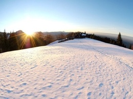
panoramic view: Great panorama
Paths covering:
Path / trail, Gravel
powered by TOURDATA
Short description:
This hike connects two popular huts with extraordinary views!
This hike connects two popular huts with extraordinary views!
Technique: **
Quality of experience: **
Recommended season:
- January
- February
- November
- December
Properties:
- Loop
- Refreshment stops available
- Summit route
Directions:
Vom Alpengasthof Klausriegler in Trattenbach führt dieser gut markierte Wanderweg stetig bergauf auf den Gipfel des Schobersteins (1.285 m) und zum Schobersteinhaus, dann weiter zur Mandlmais, zum Pfaffenboden und zur Grünburger Hütte.
Variante: Für den Rückweg bietet sich die Variante über den Pfaffenboden und Schreibachfall an.
Wanderweg: 481, 482, 483
Note: At the Alpengasthof Klausriegler you have to pay a parking fee (currently € 2,50). With consumption you get a token to drive out.
Tip:
The Schoberstein is also a popular destination for ski tourers
Safety guidelines:
Adapt your tours to the current weather and avalanche situation reports and act according to seasonal dangers in the (alpine) terrain.
Equipment:
Mountain boots, gaiters, warm weatherproof winter clothing, hiking poles, some provisions, warm drink.For the steeper sections it is advisable to bring dredges.
Starting point: Trattenbach/Gasthof Klausriegler
Destination: Trattenbach/Gasthof Klausriegler
further information:
- Flatly
- Board possible
Details - hiking
- cleared winter hiking path

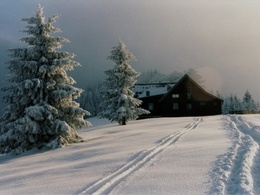
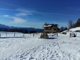
Schobersteinhaus
Most economical season
- Early winter
- Deep winter
Please get in touch for more information.
Stadtplatz 27
4400 Steyr
Phone +43 7252 53229 - 0
E-Mail info@steyr-nationalpark.at
Web www.steyr-nationalpark.at/
https://www.steyr-nationalpark.at/
Interactive elevation profile
Create PDF
Tour-Details
Starting place: 4453 Ternberg
Destination: 4596 Steinbach an der Steyr
duration: 2h 45m
length: 6,8 km
Altitude difference (uphill): 704m
Altitude difference (downhill): 277m
Lowest point: 652m
Highest point: 1.262m
difficulty: easy
condition: easy
panoramic view: Great panorama
Paths covering:
Path / trail, Gravel
powered by TOURDATA
