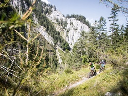
Eisenwurzenradweg R16


- Multi-day tour
Interactive elevation profile
Create PDF
Tour-Details
Path number: R16
Starting place: 3335 Weyer
Destination: 3340 Waidhofen an der Ybbs
duration: 0h 54m
length: 11,9 km
Altitude difference (uphill): 139m
Altitude difference (downhill): 32m
Lowest point: 372m
Highest point: 511m
difficulty: medium
condition: medium
panoramic view: Individual Views
Paths covering:
Asphalt, Street, Hiking trail, Other
powered by TOURDATA
Short description:
The Eisenwurzenradweg connects two historic centers of iron processing, the Enns Valley in Upper Austria and the Ybbstal in Lower Austria.
The Eisenwurzenradweg connects two historic centers of iron processing, the Enns Valley in Upper Austria and the Ybbstal in Lower Austria.
Recommended season:
- April
- May
- June
- July
- August
- September
- October
Properties:
- Multi-stage route
Starting point for your bike tour is Weyer, the "golden market" in the Enns Valley.
Directions:
For the most part on the federal road you are on the way to Gaflenz and soon reach the border to Lower Austria. Here the Eisenwurzenweg continues to Waidhofen an der Ybbs. Sections with heavier motorized traffic are marked with signs: Weyer - Gaflenz
Signposting: R16 (As part of the Upper Austrian provincial cycle path network). For the experienced cyclist!
Safety guidelines:
Inquire in advance about any trail or road closures along the route.
Equipment:
Sun and rain protection, repair kit for minor bike breakdowns.
Additional information:
You can obtain map material at www.steyr-nationalpark.at
Starting point: Gaflenz
Destination: Weyer
further information:
- Multi-day tour
Most economical season
- Spring
- Summer
- Autumn
Please get in touch for more information.
Stadtplatz 27
4400 Steyr
Phone +43 7252 53229 - 0
E-Mail info@steyr-nationalpark.at
Web www.steyr-nationalpark.at/
https://www.steyr-nationalpark.at/
Interactive elevation profile
Create PDF
Tour-Details
Path number: R16
Starting place: 3335 Weyer
Destination: 3340 Waidhofen an der Ybbs
duration: 0h 54m
length: 11,9 km
Altitude difference (uphill): 139m
Altitude difference (downhill): 32m
Lowest point: 372m
Highest point: 511m
difficulty: medium
condition: medium
panoramic view: Individual Views
Paths covering:
Asphalt, Street, Hiking trail, Other
powered by TOURDATA
