Bilderstadel Molln
Path number: 34
Starting place: 4443 Maria Neustift
Destination: 4443 Maria Neustift
Stadtplatz 27
4400 Steyr
4400 Steyr

Short description:
Wonderful hike in any season!
Wonderful hike in any season!
Quality of experience: ***
Recommended season:
- March
- April
- May
- June
- July
- August
- September
- October
- November
Properties:
Description:- Loop
From the Windhager Kores inn in Breitenau, the trail leads to Rosenegg to the Rosenegger Alm, then on through the Schneegraben and along the Hausbach stream back to the starting point.
Trail number: 34
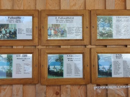
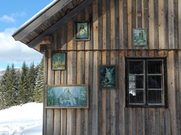
Directions:The Bilderstadel on the Rosenegger Alm is an ancient place of popular devotion and is a favorite of pilgrims. From Breitenau in Molln at the Windhager Kores inn, the route leads to the Rosenegger Alm and via the Schneegraben and Hausbach back to the starting point.Tip:
Highly recommended in winter with snowshoes!
Path number: 34
Starting place: 4443 Maria Neustift
Destination: 4443 Maria Neustift
duration: 3h 58m
length: 12,8 km
Altitude difference (uphill): 454m
Altitude difference (downhill): 468m
Lowest point: 450m
Highest point: 836m
difficulty: medium
condition: difficult
panoramic view: Individual Views
Paths covering:
Asphalt, Path / trail, Gravel, Hiking trail, Other
Starting point: Molln/Breitenau - Gasthaus Windhager Kores
Destination: Molln/Breitenau - Gasthaus Windhager Kores
further information:
- Flatly

Pferde-Erlebnisbauernhof Rohrauer
UrHof
Accessibility / arrival
Public Transit
The Steyrtal is served by bus lines 452 (Rohr-Bad Hall-Steinbach a. d. Steyr) and 433 (Steyr-Molln-Kirchdorf).
Parking
Molln/Breitenau
Getting there
From the west: A1 exit Sattledt > via Kremsmünster > Bad Hall > Steinbach an der Steyr
From the east: A1 exit Haag > Steyr > B140 into the Steyr valley
From the north: A3 Passau > Wels > A9 exit Sattledt > Kremsmünster > Bad Hall > Steinbach
From the south: A9 exit Klaus > into the Steyr valley
Public Transit
The Steyrtal is served by bus lines 452 (Rohr-Bad Hall-Steinbach a. d. Steyr) and 433 (Steyr-Molln-Kirchdorf).
Details at www.ooevv.at
With the Steyrtal Museum Railway www.steyrtalbahn.at
Parking
Molln/Breitenau
- Suitable for seniors
- Suitable for single travelers
- Suitable for friends
- Suitable for couples
- Spring
- Summer
- Autumn
- Early winter
Please get in touch for more information.
Stadtplatz 27
4400 Steyr
Phone +43 7252 53229 - 0
E-Mail reichraming@steyr-nationalpark.at
Web www.steyr-nationalpark.at/
https://www.steyr-nationalpark.at/


