Ebenforstalm from Molln/Bodinggraben
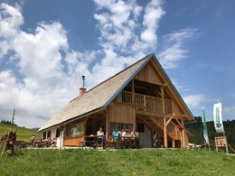
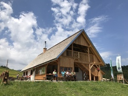


- Possible accommodation
Interactive elevation profile
Create PDF
Tour-Details
Starting place: 4591 Molln
Destination: 4591 Molln
duration: 2h 31m
length: 16,5 km
Altitude difference (uphill): 663m
Altitude difference (downhill): 663m
Lowest point: 573m
Highest point: 1.164m
difficulty: easy
condition: easy
panoramic view: Dreamtour
Paths covering:
Path / trail, Gravel, Hiking trail, Other
powered by TOURDATA
Short description:
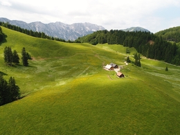
Mountain pastures and huts tour
Description:Mountain pastures and huts tour
Starting point is the parking lot Scheiblingau
Directions:
Scheiblingau parking lot - Messerer Haus turnoff - approx. 8.5 km uphill to the hiking trail turnoff - short pushing section.
Route characteristics: Bike classic with magnificent views over the Reichraminger Hintergebirge and Sengsengebirge.
Road surface: gravel.
Combination possibilities: Circular tours via Reichraming and Gaißhanslniedern or Hohe Dirn and Pfaffenboden. Connection via Hintergebirgsradweg to Anlaufalm or Mooshöhe.
Safety guidelines:
Inquire in advance about any road or trail closures along the route.
Equipment:
Sun and rain protection, repair kid for minor bike breakdowns
Additional information:
You can obtain map material at www.steyr-nationalpark.at
Starting point: Parkplatz Scheiblingau
Destination: Ebenforstalm
further information:
- Possible accommodation
details mountainbike
- Riding technique: medium
- Suitable for seniors
- Suitable for single travelers
- Suitable for friends
- Suitable for couples
Please get in touch for more information.
Stadtplatz 27
4400 Steyr
Phone +43 7252 53229 - 0
E-Mail reichraming@steyr-nationalpark.at
Web www.steyr-nationalpark.at/
https://www.steyr-nationalpark.at/
Interactive elevation profile
Create PDF
Tour-Details
Starting place: 4591 Molln
Destination: 4591 Molln
duration: 2h 31m
length: 16,5 km
Altitude difference (uphill): 663m
Altitude difference (downhill): 663m
Lowest point: 573m
Highest point: 1.164m
difficulty: easy
condition: easy
panoramic view: Dreamtour
Paths covering:
Path / trail, Gravel, Hiking trail, Other
powered by TOURDATA
