L1 Dürnbach circuit


- Flatly
Interactive elevation profile
Create PDF
Tour-Details
Paths covering:
A stretch along the Siberlbach to the waterfall (Faller Bucht) and back via Enns-Aktiv-Weg
Technique: *
Quality of experience: ***
Recommended season:
- January
- February
- March
- April
- May
- June
- July
- August
- September
- October
- November
- December
Properties:
- Loop
- Refreshment stops available
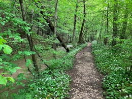
After a short stretch of road you come to the Siberlbach, along which you continue in the forest strip. After crossing a small bridge and a short ascent, you return to the top between fields and then descend to Faller Bucht (waterfall).
The rest of the loop is on a part of the Enns Aktiv trail.
Highlight is waterfall in the Faller Bucht.
Directions:
From the train station Dürnbach direction Steyr slightly downhill to the underpass of the track, on the other side turn left onto the road and follow the course slightly downhill at the intersection.
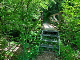
At the bottom continue straight on (slight uphill) into Lauchweg, stay on this road until the fork. There keep to the right (according to the hiking trail sign in the direction of Gasthaus Sternwirt) and continue to the end of the road. Continue on the hiking trail along the Siberlbach stream until a small wooden bridge crosses it on the left. Cross this bridge and continue straight up the climb (attention: do NOT turn right onto the hiking trail).
At the top, turn left onto the dirt road and continue to the right at the farmhouse and around the corner to the left onto the road. Stay on the road until the next bridge, after the bridge turn right through the underpass towards "Faller Bucht" (hiking trail sign). After the underpass, turn right along the stream to an old cottage, after which it goes down to the Enns and the Faller Bucht. Keep right at the bottom for the Faller Bucht.
After a short detour to the waterfall to the Enns and directly along the Enns on the Enns Active Trail continue across the meadow and then uphill. At the top through a wooden flap door, turn left between two gardens to the next short piece of road. Keep right and also turn right at the intersection. Pass the Enns Cinema Lounge and shortly after turn right onto the Wandersteig. Follow this (along the Enns River) until you come to the road and see a round chapel on the other side of the road. Turn left here and walk slightly uphill until you return to Dürnbach station.
Tip:
Faller Bucht (waterfall) - natural heritage, place of power and always worth a photo; after a long dry period it unfortunately happens that the waterfall is dried up (still beautiful).
Along from the Siberlbach in the spring very much wild garlic, which blooms in May then beautifully
Safety guidelines:
when wet in some places a little slippery
Equipment:
The required equipment always depends on the particular tour and the weather conditions. Regarding the food: This is very individual and it is recommended to have rather too much than too little with equipment and food. For a 5km round in the valley you need less than for a demanding tour in the mountains. The weather can change quickly and if you are not constantly on the move or need to take a break, for example, warming clothing is of great importance.
We have a general checklist for you here:
- Weather-appropriate running gear for the season - weather forecast - region - elevation. This includes:
* a waterproof rain jacket
* a waterproof rain trousers suitable for running
* Gloves and warm headgear (hood/headband/towel).
* sunglasses + sunscreen + headgear for very warm days
- Trail running shoes
- Drinking bottles, softflasks or a hydration bladder with enough liquid for the respective tour (if necessary also salt tablets/magnesium)
- Snacks for the energy boost in between: Energy bars, gels, chocolate, trail mix,
- Running backpack: ideally a trail running vest / a trail running backpack or a belly belt for small tours.
- Drypack: to keep your valuables or change of clothes dry (optionally a small garbage bag).
- Emergency blanket
- Small first aid kit. An Israeli bandage is highly recommended: this is a one-handed wound and pressure bandage. Details can be found here.
- Emergency whistle (often integrated in trail backpacks)
- Cell phone
- Maps (online and/or offline)
- E-card or insurance card
- Some cash
- Grödeln/Spikes: these can be a great advantage in winter and icy conditions.
- Folding poles for trail running
- Headlamp
Additional information:
This trail was run for us by Marietta Atzmüller
further information:
- Flatly
- Board possible

- Spring
- Summer
- Autumn
- Early winter
- Deep winter
Please get in touch for more information.
Stadtplatz 27
4400 Steyr
Phone +43 7252 53229 - 0
E-Mail info@steyr-nationalpark.at
Web www.steyr-nationalpark.at/
Interactive elevation profile
Create PDF
Tour-Details
Paths covering:
