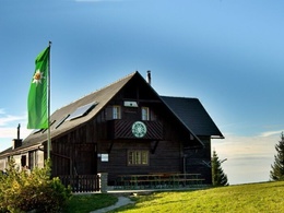
Grünburger Hütte - Steinbach/Rieserberg


- pets allowed
- Suitable for families
Interactive elevation profile
Create PDF
Tour-Details
Path number: 480
Starting place: 4596 Steinbach an der Steyr
Destination: 4596 Steinbach an der Steyr
duration: 1h 4m
length: 2,5 km
Altitude difference (uphill): 372m
Altitude difference (downhill): 4m
Lowest point: 706m
Highest point: 1.078m
difficulty: medium
condition: medium
panoramic view: Dreamtour
Paths covering:
Path / trail, Gravel
powered by TOURDATA
Short description:
Family hike in any season
Family hike in any season
Quality of experience: ***
Recommended season:
- January
- February
- March
- April
- May
- June
- July
- August
- September
- October
- November
- December
Properties:
- Scenic
- Refreshment stops available
- Family friendly
Starting from the parking lot Rieserberg, the hiking trail leads to the Wetterkreuz and on a forest road and then on a forest path over serpentines over the mountain ridge to the Grünburger Hütte.
Trail number: 480
Directions:
From the Rieserberg parking lot between Steinbach/Steyr and Molln, follow forest trail no. 480 to the Wetterkreuz cross. Continue hiking on a forest road to a large meadow and then on a forest path over serpentines up the mountain to the ridge and the Grünburger hut.
The Grünburger hut invites you to a beautiful view over the foothills of the Alps. Popular but steep ascent to the Grünburger hut, sturdy shoes are therefore recommended.
The children are accompanied by Zwergerltafeln and so the climb is much easier.
Starting point: Steinbach an der Steyr/Forstau - parking Rieserberg
Destination: Steinbach an der Steyr/Grünburger Hütte
further information:
- Board possible
Accessibility / arrival
Public Transit
The Steyrtal is served by bus lines 452 (Rohr-Bad Hall-Steinbach a. d. Steyr) and 433 (Steyr-Molln-Kirchdorf).
Parking
Steinbach an der Steyr/parking Rieserberg - Forstau
Getting there
From the west: A1 exit Sattledt > via Kremsmünster > Bad Hall > Steinbach an der Steyr
From the east: A1 exit Haag > Steyr > B140 into the Steyr valley
From the north: A3 Passau > Wels > A9 exit Sattledt > Kremsmünster > Bad Hall > Steinbach
From the south: A9 exit Klaus > into the Steyr valley
Public Transit
The Steyrtal is served by bus lines 452 (Rohr-Bad Hall-Steinbach a. d. Steyr) and 433 (Steyr-Molln-Kirchdorf).
Details at www.ooevv.at
With the Steyrtal Museum Railway www.steyrtalbahn.at
Parking
Steinbach an der Steyr/parking Rieserberg - Forstau
- Suitable for schools
- Pets allowed
- Suitable for teenagers
- Suitable for single travelers
- Suitable for friends
- Suitable for couples
- Suitable for children
- Spring
- Summer
- Autumn
- Early winter
- Deep winter
Please get in touch for more information.
Stadtplatz 27
4400 Steyr
Phone +43 7252 53229 - 0
mobile +43 660 8466253
E-Mail gruenburgerhuette@gruenburgerhuette.or.at
Web www.steyr-nationalpark.at/
Web www.gruenburgerhuette.or.at
https://www.steyr-nationalpark.at/
http://www.gruenburgerhuette.or.at
http://www.gruenburgerhuette.or.at
Interactive elevation profile
Create PDF
Tour-Details
Path number: 480
Starting place: 4596 Steinbach an der Steyr
Destination: 4596 Steinbach an der Steyr
duration: 1h 4m
length: 2,5 km
Altitude difference (uphill): 372m
Altitude difference (downhill): 4m
Lowest point: 706m
Highest point: 1.078m
difficulty: medium
condition: medium
panoramic view: Dreamtour
Paths covering:
Path / trail, Gravel
powered by TOURDATA
