Lynx Trail - Stage 06 Johnsbach - Ennstalerhütte Lodge, Standard


- Multi-day tour
Interactive elevation profile
Create PDF
Tour-Details
Paths covering:
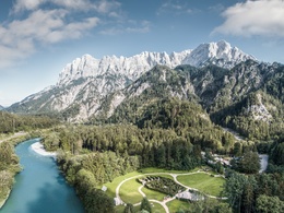
Through the center of the Gesäuse National Park (Willow dome Adventure Center, Gstatterboden) to the Ennstalerhütte lodge
Quality of experience: ******
Recommended season:
- May
- June
- July
- August
- September
- October
Properties:
- Multi-stage route
- Scenic
- Refreshment stops available
There is a more difficult and longer way of Stage 6: Lynx Trail Stage 06 Johnsbach - Ennstalerhütte - DIFFICULT
Directions:
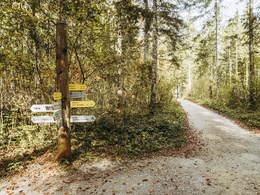
Leaving your chosen accommodation in Johnsbach, you start out by walking along the Schattseitenweg trail, which runs south of the motorway, until you reach the ‘Gasthof zum Donner’ country inn. Seeing as today involves only a short trek, you have plenty of time for a visit to the Johnsbach Cemetery, 5 minutes’ walk from the inn’s car park. Famed as Austria’s largest mountaineers’ cemetery, these hallowed grounds emanate a melancholic yet mesmerising beauty. Numerous historical gravestones tell the stories of young men who lost their lives in the Gesäuse mountains – the first of whom was buried here 200 years ago. Despite the tragedy involved, you cannot help but feel a strange sense of peace within the idyll of the surrounding landscape. Continuing your journey from the ‘Gasthof zum Donner’ inn, you take the Sagenweg trail – following the course of the Johnsbach stream towards the Weidendom indoor and outdoor visitor’s centre located at the confluence of the Johnsbach and the Enns. The final 1.5 km of this stretch was redesigned in 2010 as an educational trail dedicated to ‘Wild John’ – a synonym for the Johnsbach stream. According to folklore, ‘Wild John’ was, in fact, a real-life giant. Today, an oversized swing, huge sandpit and enormous picnic area provide a delightful reference to this old folkloric tale. We highly recommend a visit to the centre’s Willow Dome as well as the Hedge Maze – two stunning, living structures that beautifully reflect the area’s commitment to sustainability. There are several inviting relaxation spots dotted around the park, while a wooden walkway takes visitors into the enchanting woodlands of the Lettmair Au. Your itinerary should leave plenty of time to fit in this worthwhile exploration (duration: approx. 30 min). When you are ready to continue with your journey, you cross the Enns river on a footbridge, before taking the Rauchbodenweg trail to Gstatterboden, always following the flow of the Enns. Hiking along this wild river in the heart of the National Park, flanked by the steep cliffs of the Buchstein and Ödstein mountains, feels a little like walking through Yosemite Valley. And, just like America’s famous Yosemite National Park, the Gesäuse mountains have played a pivotal part in the evolution of climbing over the past 100 years – so much so that they are known as Austria’s ‘mountaineering academy’. Once you have reached the hamlet of Gstatterboden we suggest a visit to the National Park Pavillon to explore current exhibitions, and find out more about the natural world of the Gesäuse mountain chain and National Park.
Directly in Gstatterboden begins the ascent to the Ennstalerhütte, where you have to overcome 1000 meters of altitude. After an hour's walk past the Hubertus Chapel, you come to the Kroiss'n trail junction. Here you follow the left direct trail no. 646/608 over the Hörandalm and the Butterbründl to the Landlereck trail junction on the saddle just below the Ennstalerhütte. This is the oldest refuge in the Gesäuse and offers a magnificent view of the surrounding mountains. Above all, the impressive peaks of the Hochtor chain stand before you as if strung on a string of pearls.
Tip:
For more information:
We recommend that you make contact with the Lynx Trail Info & Booking Centre before making a booking.
Find a deal at:
Safety guidelines:
Mountain Rescue 140
Equipment:
Sturdy mountain walking boots or trail shoes, as well as a rucksack packed with essentials (water bottle, plasters for blisters, trail map, food etc.). You should also be well prepared for changes in the weather. If you are staying overnight in mountain huts don’t forget your sleeping bag!
Additional information:
Hints and tips
Lynx Trail Info & Booking Centre
Trail Angels GmbH
Obervellach 15, 9821 Obervellach
Tel.: +43 47 82 93 093
Web:
Email: info@bookyourtrail.com
Lower Austria Information Office:
Mostviertel Tourismus GmbH
Töpperschloss Neubruck
Neubruck 2/10, 3283 Scheibbs
Tel.: +43 (0) 7482 204 44
Email: info@mostviertel.at
Upper Austria Information Office:
Tourismusverband Nationalpark Region Ennstal
Eisenstraße 75, 4462 Reichraming
Tel.: +43 (0) 7254 8414
Email: info@nationalparkregion.com
Steiermark Information Office:
Tourismusverband Gesäuse
Hauptstraße 35, 8911 Admont
Tel. +43 (0) 3613 21160 10
Email: info@gesaeuse.at
further information:
- Multi-day tour
- Board possible


Getting there
Public Transit
In the Gesäuse you are mobile even without your own car
One call to t: +43 3613 21 000 99 is enough: During operating times, you can take the Gesäuse Sammeltaxi to any destination in the Gesäuse, without any timetable or stops.
Further information & operating times
Timetable inquiry at www.oebb.at or www.busbahnbim.at
Parking
Parking facilities are available at the respective starting points, which are subject to a charge, especially in the Gesäuse National Park area.
Tip: Please leave a note in your car with your telephone number and the date of your return, together with a note that you are on a hike lasting several days. The mountain rescue service will thank you!
- Spring
- Summer
- Autumn
Please get in touch for more information.
Interactive elevation profile
Create PDF
Tour-Details
Paths covering:
